Circular Walk around Thurne
This is a fantastic walk to explore the countryside around Thurne and see the mill that makes this village so famous on the Broads. There is plenty of wildlife to look out for along the river as well as in the marshes and woodlands around it.
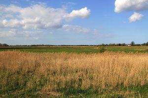
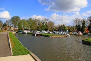
This is a fantastic walk to explore the countryside around Thurne and see the mill that makes this village so famous on the Broads. It starts off at Thurne Staithe where there is a small car park and plenty of moorings. It follows the dyke towards the River Thurne where you pass the white painted Thurne Dyke Drainage Mill. This is one of the most photographed mills in the area and was built in 1820. In 1949 the windmill was bought by Bob Morse and was eventually restored with assistance from the Norfolk Windmills Trust. After passing the mill the route follows a section of the Weavers Way beside the River Thurne all the way to Repps Staithe. There is plenty of wildlife to look out for along the river as well as in the marshes and woodlands around it. From Repps Staithe the route follows a short section of country lane and then footpaths across open fields towards Shallam Dyke near Abbey Farm. From there its a simple mixture of country lanes and footpaths back to Thurne Staithe via Home Farm.
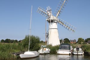
1) From Thurne Staithe follow the riverside footpath along the moorings towards the River Thurne until you arrive at the white painted Thurne Dyke Drainage Mill. Once at the Mill the public footpath follows a raised bank along the River Thurne round to the right. This section follows part of the Weavers Way long distance path and continues for just under 2 miles (3.0km) all the way to Repps Staithe. You know when you are nearing the end of this section when you start following the path behind a dozen or so waterside properties.
2) The first country lane on the right is the one you want which is Staithe Road. The country lane heads away from the River Thurne and through a section of the village of Repps. Follow the road for about 1/3 of a mile (just under 600 metres) and you will see a footpath heading off to the left and to the right.
3) You need to turn right here and follow the footpath in a straight line through the open field and up to an area of woodland. The path heads into the woodland and bends round to the right to start heading west. Just by this bend there is a footbridge on the left. Head over the footbridge and then turn left to follow a path along the edge of the field which will take you to a country lane.
4) Once at the road you need to turn right and follow it for about 1/3 of a mile (about 550 metres) where you will see a public footpath on the left which heads diagonally through the field. Follow this path and after a few minutes it will join another path coming in from right to left. Turn left and follow this path south until you arrive at a track about 200 metres away. Once at the straight track turn right and follow it in the direction of Home Farm. The path joins the farm track and takes you round to the left and then to the right through the farmyard and you will eventually come out on a country lane close to Thurne Dyke. Turn right and then on the left is the narrow lane down Thurne Dyke.
Route and photographs supplied by Joe Jackson.