Discover the Norfolk Broads by Bike
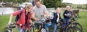
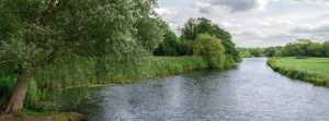
Experience the serene beauty of the Norfolk Broads on two wheels. With its flat landscapes, picturesque villages, and a network of dedicated cycle paths, the Broads offer some of the most enjoyable cycling experiences in the UK. Whether you’re a seasoned cyclist or just looking for a leisurely ride, there’s a route for everyone. Below are some of the best cycling routes to explore in the area.
Bungay to Geldeston, Beccles, Barsham, and Ilketshall St Andrew
Distance: Approximately 25 miles
Duration: Around 4 hours
Difficulty: Moderate (mostly flat but primarily on roads)
Route Description
Start your journey in the charming market town of Bungay, known for its historic Thursday market, running since 1382. From the town center, take the old railway line parallel to the A143 towards Ellingham. Before reaching the village, turn right onto the road leading to Geldeston. Continue right onto Dunburgh Road towards Gillingham.
As you enter Beccles, head towards the Old Bridge, then follow the road out of town. You’ll join a scenic bike path through the countryside, rejoining the road near Barsham. Proceed along Hall Road to Ilketshall St Andrew, cross Ilketshall Old Commons, and head towards Mettingham Castle. Continue along Castle Road, cross Wainford Lock, and return to Bungay.
Highlights
Ellingham Mill and Lock: A picturesque spot perfect for a quick rest.
Locks Inn in Geldeston: A historic pub first licensed in the 1600s.
Mettingham Castle: Admire the impressive walls and outer gate of this historic site.
Facilities
Refreshments: Pubs and cafes in Bungay, Beccles, Geldeston, and Gillingham.
Parking: Multiple car parks available in Bungay.
Bungay to Geldeston via Earsham, Ditchingham, and Ellingham
Distance: Approximately 12 miles
Duration: Around 2 hours
Difficulty: Easy (mostly flat with some road cycling)
Route Description
Begin at Outney Common near Bungay, leaving your car at the common’s car park. Cross under the A143 and turn right onto Earsham Dam. Continue straight, then turn right under the main road towards Ditchingham. Cycle south back towards the A143, turning left onto the bike path parallel to the road. Upon reaching Ellingham Mill and Lock, you can either return to Bungay or proceed to Geldeston Lock.
Highlights
Outney Common: A beautiful area rich in wildlife.
St Mary’s Church in Ditchingham: Linked to author Ryder Haggard.
Ellingham Mill and Lock: A serene spot with historical significance.
Locks Inn in Geldeston: A historic riverside pub.
Facilities
Refreshments: Pubs and shops in Bungay, Earsham, and Geldeston.
Parking: Available at Outney Common.
Burgh St Peter Staithe to Aldeby, Raveningham, Thurlton, and Haddiscoe
Distance: Approximately 19 miles
Duration: Around 3 hours
Difficulty: Moderate (mix of country roads and some off-road sections)
Route Description
Start at the Waveney River Centre, equipped with parking, toilets, and a café. Head along Middle Lane towards Burgh St Peter, continue through the village towards Toft Monks, then to Raveningham. Turn right towards Thurlton, stay on Low Road along the marshes, then proceed to Aldeby and Wheatacre. Cycle down Burgh Road, offering stunning marsh views, back to the Waveney River Centre.
Highlights
Waveney River Centre: A hub for activities and learning about the Broads.
Raveningham Hall: A beautiful estate with over 5,500 acres to explore.
Thurlton and Haddiscoe Marshes: Ideal for wildlife spotting and enjoying expansive views.
Facilities
Refreshments: Pubs in Burgh St Peter, Toft Monks, Thurlton, and Haddiscoe.
Parking: Available at Waveney River Centre.
Transport: Nearby train stations at Haddiscoe and Reedham.
Burgh St Peter Staithe to Aldeby, Toft Monks, and Wheatacre
Distance: Approximately 11 miles
Duration: Around 2 hours
Difficulty: Easy (suitable for all fitness levels)
Route Description
Begin at the Waveney River Centre. Keep left onto Staithe Road, then left onto Grays Road around Burgh St Peter. Continue onto St Mary’s Road towards Aldeby. Optionally, explore Three Gates Wood or proceed to Aldeby Staithe. Cycle to Toft Monks for a pub stop, then head towards the old Aldeby Railway Station. Turn right onto Station Road, left onto Burgh Road, and return to the starting point.
Highlights
Three Gates Wood: Perfect for a nature walk and wildlife spotting.
Aldeby Hall: Offers a scenic half-hour walk through the estate.
Stanley Hills: An Ice Age-formed heathland with unique flora and fauna.
Facilities
Refreshments: Pubs in Toft Monks and Burgh St Peter.
Parking: Available at Waveney River Centre.
Transport: Bus stop in Wheatacre; train stations in Beccles and Haddiscoe.
Clippesby to Potter Heigham, How Hill, and Ludham
Distance: Approximately 14.5 miles
Duration: Around 2 hours
Difficulty: Easy to Moderate (some narrow roads)
Route Description
Start in Clippesby, cycling down Hall Lane, right onto Manor Farm Road, then onto Repps Road through Repps towards Potter Heigham. Navigate up Market Road, Elderbush Lane, and Sharp Street to How Hill Nature Reserve. Continue to Ludham, where you can visit St Benet’s Abbey before returning to Clippesby.
Highlights
How Hill Nature Reserve: Explore walking trails and guided boat trips.
St Benet’s Abbey: Historic monastery ruins with a unique windmill structure.
St Benet’s Level Mill and the Toad Hole Cottage Museum: Offering insights into local history.
Facilities
Refreshments: Cafés, pubs, and toilets in Clippesby, Potter Heigham, Ludham, and Ludham Bridge.
Parking: Available in Clippesby.
Hickling to Sutton
Distance: Approximately 5.5 miles
Duration: Around 1 hour
Difficulty: Easy (ideal for all fitness levels)
Route Description
Begin at the Norfolk Wildlife Trust Nature Reserve in Hickling. Cycle out to Stubb Road, turn left towards Hickling Green, then right onto The Causeway to Hickling village. Turn right on Eastfield Road, left past St Mary’s Church, through Hickling Green, and left on New Road towards Sutton. Return via Sutton Road to Hickling Heath and back to the reserve.
Highlights
Norfolk Wildlife Trust Nature Reserve: A haven for birdwatchers and nature lovers.
St Mary’s Church: A historic church dating back to the Domesday Book.
Sutton Mill: The tallest corn mill in Britain.
Facilities
Refreshments: Pubs in Hickling Green, Sutton, and Hickling Heath.
Parking: Available at the Nature Reserve.

Horning to Wroxham, Salhouse, and Ranworth
Distance: Approximately 23.5 miles
Duration: 3 to 4 hours
Difficulty: Moderate (mostly on roads with some bridleways)
Route Description
Start at BeWILDerwood in Horning. Turn left on St Peters Lane to Hoveton Hall Gardens, then left towards Hoveton village. Pass through Wroxham and Wroxham Broad, turning left towards Salhouse and Woodforde’s Brewery. Proceed to Ranworth, visiting Ranworth Staithe and NWT Conservation Centre, then cycle back through Town Green and Salhouse to Horning.
Highlights
BeWILDerwood: A magical forest adventure for all ages.
Hoveton Hall Gardens: Beautiful lakeside and woodland walks.
Ranworth Broad and Staithe: Ideal for wildlife spotting and boating.
Woodforde’s Brewery: Tour and taste some of Norfolk’s finest brews.
Facilities
Refreshments: Cafés, pubs, and toilets in Horning, Hoveton, Salhouse, and Ranworth.
Parking: Available at BeWILDerwood.
Transport: Train station in Hoveton.
Horsey to Sea Palling, Hickling, and Potter Heigham
Distance: Approximately 20 miles
Duration: Around 4 hours
Difficulty: Moderate (windy conditions may add challenge)
Route Description
Starting in Horsey, cycle north to Sea Palling, passing Waxham Barn. Turn left on Hickling Road to Hickling Green, then south along Potter Heigham Road to Potter Heigham. Turn left on Bridge Road towards Martham, then left on Horsey Road back to Horsey.
Highlights
Horsey Windpump: Historic windpump with panoramic views.
Sea Palling Beach: Golden sands perfect for a seaside break.
Hickling Broad: Explore the Norfolk Wildlife Trust Nature Reserve.
Facilities
Refreshments: Pubs, car parks, and toilets in Horsey, Sea Palling, Hickling Green, and Potter Heigham.
Parking: Available in Horsey and along the route.
Hoveton to Neatishead, Barton Turf, and Horning
Distance: Approximately 16 miles
Duration: Around 2 to 3 hours
Difficulty: Easy to Moderate (mostly flat terrain)
Route Description
Begin at BeWILDerwood, turning left on St Peters Lane to Belaugh Green. Right on Belaugh Lane past Wroxham Barns to Butcher’s Common. Turn onto Cangate Road to Neatishead, loop past Pennygate, then south past Irstead Street to Horning.
Highlights
BeWILDerwood: A whimsical adventure park.
Wroxham Barns: Crafts, shops, and a café.
Barton Broad: Nature trails and wildlife spotting.
RAF Air Defence Radar Museum: Dive into military history.
Facilities
Refreshments: Pubs and cafés in Horning, Neatishead, and Wroxham Barns.
Parking: Available at BeWILDerwood.
Transport: Train station in Hoveton.

Martham to Thurne, Rollesby, and West Somerton
Distance: Approximately 15 miles
Duration: Around 3 hours
Difficulty: Easy (suitable for most cyclists)
Route Description
Start in Thurne, head north on The Street, right on Repps Road, left at the T-junction, then right onto Church Road. Proceed to Martham, turn left on Black Street, right on Staithe Road to West Somerton. Return via Martham and Rollesby back to Thurne.
Highlights
Thurne Windmill: Iconic mill with scenic views.
St Edmund’s Church: 13th-century historical site.
Rollesby Broad: Tranquil spot ideal for picnics and birdwatching.
Facilities
Refreshments: Pubs in Thurne, West Somerton, and Martham.
Parking: Available in Thurne.
Stalham to Ingham and Worstead
Distance: Approximately 23 miles
Duration: 3 to 3.5 hours
Difficulty: Moderate (some off-road sections)
Route Description
Begin at Sutton Staithe, cycle north to Stalham, then towards Ingham. Continue to Lessingham, Happisburgh Common, and Crostwight, then south to Honing. Optional loop through Briggate, Lyngates, Sloley Frankfort, and Dilham before returning.
Highlights
Ingham Church and Priory Ruins: Rich in history.
Old Vicarage Gardens: Stunning horticultural displays.
Worstead Village: Birthplace of Worsted cloth.
Facilities
Refreshments: Pubs in Sutton Staithe, Stalham, Ingham Corner, Lessingham, Worstead, and Dilham.
Parking: Available at Sutton Staithe.
Transport: Train station in Sloley.
Stokesby to Runham, Mautby, and Thrigby
Distance: Approximately 8.5 miles
Duration: Around 1.5 hours
Difficulty: Easy (mostly flat and on quiet roads)
Route Description
Start in Stokesby, cycle on Runham Road through Runham to Mautby. Left on Mill Road, right on Thrigby Road towards Filby Broad. Explore the broad or return via Thrigby Road and Winsford Hall back to Stokesby.
Highlights
St Andrew’s Church in Stokesby: 13th-century thatched church.
Halvergate Marshes: Europe’s largest grazing marsh.
Thrigby Wildlife Gardens: Home to Asian mammals, birds, and reptiles.
Filby Broad: Peaceful spot for nature enthusiasts.
Facilities
Refreshments: Café and pub in Stokesby, pub in Filby.
Parking: Available in Stokesby.
Three Rivers Loop from Loddon
Distance: Approximately 20 miles
Duration: Around 4 hours
Difficulty: Moderate (mix of terrains)
Route Description
Starting in Loddon, head east on Norton Road, cross Loddon Road and Ferry Road. Option to detour via Reedham Ferry and Ferry Inn. Proceed through Hales, down Beccles Road to Raveningham Road. Before Beccles, turn left under the A146 to Geldeston, then past Ellingham back to Loddon.
Highlights
Loddon Staithe: Historical mooring site.
Chet Valley and Hardley Floor: National Trust site rich in wildlife.
Raveningham Hall: Estate with beautiful gardens (check opening times).
Facilities
Refreshments: Pubs in Loddon, near Reedham Ferry, and in Geldeston.
Parking: Available in Loddon.
Transport: Train stations in Reedham and Beccles.
Plan Your Adventure…
Cycling is one of the best ways to experience the natural beauty and charm of the Norfolk Broads. With routes suitable for all levels and plenty of attractions along the way, you’re sure to have an unforgettable journey. Don’t forget to check out local amenities and plan your stops to make the most of your trip.
Discover more about cycling routes and attractions in the Norfolk Broads by exploring our site. Happy cycling!